The trail we were hiking was high above the creek bottom. This gave us a great vantage to look down on some of the open spaces of grassy meadows dotted with a few juniper trees and rocks.
In one section of brush maybe 50 yards away, I spotted large, donkey-like ears poking up. I studied it for a minute and noticed a long face staring up at me. It was a moose bedded down in the grass and brush. It seemed to be looking at us and wondering if we were something to worry about.
Julie and I were out on an afternoon hike up Bear Creek on the southwest side of Palisades Reservoir last week. It was one of those spring days when you got a dose of nearly every kind of weather. The temperatures weren’t too bad when it was sunny, but then it would change to cloudy, windy, sprinkle a bit of snow, think about raining and go back to being pleasantly sunny — all in the space of half an hour.
The moose was about 2.2 miles up the canyon and started to stand and move after we gawked at it, snapped photos and asked it how it was doing. It appeared to be on the skinny side and had odd discolorations. Sadly, I think the creature was having some health issues.
All of the peaks in the region were still snow-covered above 8,000 to 9,000 feet. There’s still plenty of snow to melt off. Bear Creek is running high with murky spring flows. It will be a while before it becomes appealing to hiking anglers.
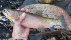
Bear Creek can be a fun fishing outing in late spring and early summer when spawning cutthroat trout swim up the creek. The spawners return back to the reservoir usually shortly afterward. There is a resident population of trout in the stream, but they tend to be smaller.
A few horseback riders have already braved the stream crossings this year. Hikers can avoid the several stream crossings on trails built higher along the canyon. I would rate the trail easy to moderate most of the way.
The trail is also open to mountain bikes and motorbikes.
At 2 miles up the trail, the canyon widens to some nice meadows and you come to the Forest Service Currant Creek station. Getting to the cabin requires crossing the stream.
About another 3 miles up the creek, you come to the North and South forks of Bear Creek. The trail forks here and the North Fork trail eventually leads to the Fall Creek trail system. The South Fork trail continues all the way to Skyline Ridge Road. Expect several stream crossings along the South Fork route. Unless you’re on a horse, the stream crossings can be a problem until the creek calms down in mid-summer.
Bear Creek is a popular trail in summer and is usually day-hiked or biked, but farther up the canyon, there are some attractive backpacking campsites. Julie was picking out a few sites to put her tent on an overnighter.
A good resource for directions for this trail and other regional trails can be found on the Caribou-Targhee National Forest website. Look for the summer recreation map and guide.
Jerry Painter is a longtime East Idaho journalist and outdoorsman.