Mixing it up on Wyoming rock climbing walls

On our last day of a three-day climbing trip, my sweetheart Julie was happy to proclaim, “I climbed my three routes today without hanging (on the rope).”

As a group, we decided to mix things up.

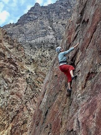
Last week my sweetheart and I were joined by my youngest son Sam and his wife in Lander, Wyoming, for three days of rock climbing during the International Climbers’ Festival. Later, we were joined by more friends.

In the Lander area, there are several amazing dolomite limestone cliff bands that attract rock climbers from around the country and even internationally. It’s one of my all-time favorite places to climb. There are about a thousand bolted routes in the area.

In years past we traditionally fell into a pattern of tried and true walls to focus on. We returned to the same walls and routes year after year, like an ingrained migration pattern. This year we deliberately changed directions. Why not? Even though we’d been to the area for about 20 years, there were still several places we hadn’t climbed and some new walls had been added to the list. Local route developers are still busy adding new routes and new walls to the list of dozens of walls in the area.

So, we bought an updated guidebook (2018) and launched off into the unknown.

Our first day we climbed at the OK Corral at Wild Iris on the edges of the Wind River Mountain Range. We’d been to the OK Corral before, but we were looking for unfamiliar routes. Many of the names and places in the area pick Western themes often with cowboy flavors because of the local ranching tradition. (The T-shirt they gave out for the festival had the image of a woman climbing a rock wearing a Stetson and cowboy boots.)

Sam had a new, unused rope that he wanted to christen on a noteworthy route. His first climb of the day was called Poker Face Alice (a long-standing standard test piece we had never tried). Unfortunately, it was not a warmup route — rated a difficult 5.12 — for experts only. The first half was easy, then the climb went under a horizontal bulge. Sam and I both gave it a whirl with predictable results. It was like being spanked with a buggy whip. Our arms and hands felt like they’d been stepped on by an Angus bull. But it was still fun taking giant falls out into space.

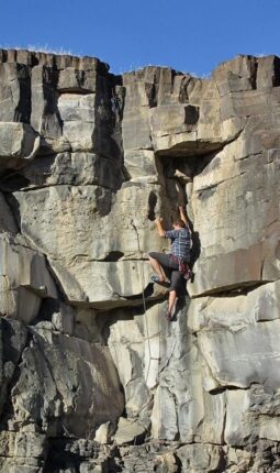
Another area we had usually passed over at the OK Corral was the Tribal War wall. One of my favorite climbs of the trip was at this wall — a challenging moderate route with plenty of pockets in the rock to keep it doable.

The next day we went to Sinks Canyon and instead of hiking up to the north side of the canyon like we have in years past, we headed to the shady south side, reputed to have shade all morning until 3 p.m. Despite the four-day festival bringing hundreds of rock climbers to the area, we shared the entire wall with two other climbers till it was nearly quitting time.

With our new climbing guidebook, we were a bit confused as to which route was which at this wall. Apparently, some new routes were added to the wall since the book was published. Guidebooks are always trying to hit a moving target. There were plenty of routes to keep our group of seven with four ropes busy until the sun finally started to blast the wall.

Lander is great for dirt-baggers. You can camp for free in the city park for three days (there are lots of grass and mature trees similar to Tautphaus Park in Idaho Falls). There’s also free camping at Wild Iris, which can be cooler because of its 8,000-foot elevation.

Sinks Canyon is about a 10- to 15-minute drive outside of Lander with another 15 to 30 minutes of hiking depending on the wall you’re heading to. Wild Iris is a 30- to 45-minute drive south of town with anywhere from 5 to 25 minutes of hiking depending on the wall you’re going to. There are several other developed areas near Lander that add up to a lifetime of climbing and hiking possibilities. Lander is about a 4.5-hour drive from Idaho Falls.

When your hands and arms get worn out from climbing, there’s always backpacking into the nearby world-class Wind River Range.

Jerry Painter is a longtime East Idaho journalist and outdoorsman.

Enjoying some miserable fun on a rainy century ride

There are three categories of outdoor fun: type one, type two and type three.

Type one fun requires only a little effort. Mostly just show up and enjoy yourself. Type two fun involves much more effort, some sweating, a few bumps and bruises and maybe a few moments of terror before the activity is over, but when you look back on it, you remember the whole outing as a worthy, memorable adventure. Type three “fun” can be good old-fashioned misery, physical and mental pain, seriously wondering if you will survive and often a visit afterward to the emergency room.

I’m not too proud to say I have indulged in all three categories of outdoor fun on a regular basis.

Last Saturday’s activity (May 28) I’m ranking at about 2.3 on the fun scale.

It started with me getting out of bed at 4:45 a.m. and checking the weather forecast for Pocatello (for the 15th time).

I had signed up for the Tour of Marsh Creek Valley century bike ride starting in Pocatello and going 50 miles south toward Downey and McCammon, then returning back.

Normally about 60 to 100 cyclists sign up for the event and ride one of three distances: 25, 60 or 100 miles.

I signed up for the 100-mile ride. The weather forecast was calling for a cold rain all day. Highs would be in the low 50s. The forecast unfortunately turned out to be spot on.

The ride started at the Pocatello Community Charter School at about 7 a.m. Normally the parking lot is jammed with cars, people unloading bikes and making last-minute preparations to ride. When I walked up to the sign-up table which had been moved into the school lobby to get out of the rain, there were only a few people standing around.

“Are you still going to ride?” an organizer asked.

I thought I detected a hint in her voice of “We’d prefer that everyone would just go home.”

The ride organizer said 29 people had preregistered for the ride and normally another 20 to 30 would join the morning of the ride. Despite the advance sign-ups, only nine people showed up to ride; five of us wanted to ride the 100-mile route. One was a woman named Beth.

As the five of us headed down the road, Beth (from Kimberly, Idaho) told me she was training for the Celtman Extreme Scottish Triathlon in Scotland.

“Riding in this cold rain will probably be the same conditions as Scotland,” she said.

She had a real reason to embrace the misery, but what was I doing here? Some people are just tougher.

After riding along for about 20 miles, my hands and feet were cold and wet. My face was dripping with the spray from fellow cyclists’ wheels. I was spitting grit from my mouth. My clear safety glasses offered only a bleary view of the world. I was stuck in the soggy spin cycle.

I was wearing a full rain suit that I brought along at the last minute “just in case” and was glad I did. Without it, I don’t think I could have done it.

After an hour, I was thinking how awful it would be to have a flat tire in the pouring rain. Then about 5 miles later, my rear tire flatted. I quickly changed it and rode fast to catch up with the other four riders who slowed some.

About every 20 to 30 miles, we stopped at a feed station with smiling and enthusiastic people serving us bananas, orange slices, salty snacks and water. Although I wasn’t particularly hungry, I forced myself to eat some bananas.

After passing McCammon heading back, I noticed a helpful tailwind that pushed our average speed up.

I found that after stopping at a feed station, it took a few miles for my body to warm back up. At the last feed station in Inkom, there was an offering of little cups of dill pickles and pickle juice. All the bikers scarfed them up, knowing that the salty vinegar would help stave off cramps.

At one point, riding along in the light rain south of Inkom, we passed a smiling man carrying two giant trout dangling from one hand and a fishing rod in the other. He pulled the fish out of the adjacent Marsh Creek.

About 5 miles south of Pocatello, my rear tire went flat again. Beth’s husband, who was following behind us in his car, jumped out and pumped up the tire. The tire only stayed inflated for about a mile before needing to be pumped up again. I was out of good tubes and didn’t want to pull the tire apart and patch it. We did the pump thing three more times. After the last time, the tire wouldn’t hold any air, and since I could see the charter school a few blocks away, I just started walking. My walking route was more direct than the bike route, and when I arrived at the parking lot, my bike computer said I had traveled 99.8 miles.

Driving back to Idaho Falls, it took several miles with the car heater on high to warm up my toes.

Jerry Painter is a longtime East Idaho journalist and outdoorsman.

Getting a taste of a few days of summer

I felt summer hit at about 4 p.m. on Saturday, May 14, out along the South Fork of the Snake River near Wolf Flats.

It wasn’t a long summer. It only lasted till the following Wednesday. A four-day summer.

By the next day (Sunday) people were hunting for shorts and sunglasses. On Monday the roads were sprouting bicycles — Dave’s Bike Shop held its first Monday evening group ride.

“It’s the first time this year the weather has been good enough,” Dave Wilding said.

I joined that Monday night ride and thought I was doing great hangin’ with the A-minus riders (or the B-plus riders depending on your point of view). Then I got a flat tire. At least I wasn’t the guy who crashed on his bike and was knocked out briefly. Bike and rider are reportedly doing fine.

On Tuesday I was seeing kids playing in front yard sprinklers to beat the summer heat — it was 75 degrees.

By Wednesday, I overheard people talking about planting their gardens. “I’m just going to do it,” they said, “and hope it doesn’t frost again.”

But speaking of frost, on Thursday and Friday, summer vanished and low temperatures dropped back down into the 30s. Summer is predicted to return this coming week, at least for a few days.

The on-again, off-again nice weather has allowed me to get outside and do some hiking, biking and rock climbing.

I’m trying to whip my old man’s body into shape for the upcoming Tour of Marsh Creek Valley century ride planned this coming weekend in Pocatello. They also have a shorter 26-mile loop and a 60-mile loop offered. Find information on the ride at www.bikereg.com/Confirmed/55411.

Also, this coming weekend is the Angry Horse gravel bike ride and race in the Bone area. Three distances are offered. For information on that event, go to theangryhorse.athlete360.com.

Trail-running friends reported that the Upper Palisades Lake along the popular Palisades Creek Trail was still partially frozen this past week. Expect plenty of snow on the trail above the lake going into Waterfall Canyon.

Grand Teton National Park closed the Baxter’s Pinnacle area to public entry to protect nesting peregrine falcons.

The Baxter’s Pinnacle area is on the west side of Jenny Lake in the park backcountry. The closure also includes the social trail that branches from the horse trails and serves as the approach route to the pinnacle that is popular with rock climbers. The closure usually lasts at least through June unless the birds abandon the nests early.

The park has lifted its winter wildlife closure protecting bighorn sheep habitat.

“Conditions in the backcountry remain winter-like,” the park blog said last week. “The valley trails are in difficult shape, with significant snow coverage throughout and many lakes are still partially covered in ice. Above 8,000’ the Teton Range remains in full winter conditions. Travelers should be cautious while traveling in the backcountry, and be prepared to deal with elevated avalanche danger during warm afternoons and when overnight lows remain above freezing.”

If you don’t mind sleeping in the snow, you can get backcountry camping permits at the park’s visitor center at Moose, Wyoming. The center also has up-to-date information on park trail conditions.

Jerry Painter is a longtime East Idaho journalist and outdoorsman.

Bear Creek Trail offers great spring hiking

The trail we were hiking was high above the creek bottom. This gave us a great vantage to look down on some of the open spaces of grassy meadows dotted with a few juniper trees and rocks.

In one section of brush maybe 50 yards away, I spotted large, donkey-like ears poking up. I studied it for a minute and noticed a long face staring up at me. It was a moose bedded down in the grass and brush. It seemed to be looking at us and wondering if we were something to worry about.

Julie and I were out on an afternoon hike up Bear Creek on the southwest side of Palisades Reservoir last week. It was one of those spring days when you got a dose of nearly every kind of weather. The temperatures weren’t too bad when it was sunny, but then it would change to cloudy, windy, sprinkle a bit of snow, think about raining and go back to being pleasantly sunny — all in the space of half an hour.

The moose was about 2.2 miles up the canyon and started to stand and move after we gawked at it, snapped photos and asked it how it was doing. It appeared to be on the skinny side and had odd discolorations. Sadly, I think the creature was having some health issues.

All of the peaks in the region were still snow-covered above 8,000 to 9,000 feet. There’s still plenty of snow to melt off. Bear Creek is running high with murky spring flows. It will be a while before it becomes appealing to hiking anglers.

Bear Creek can be a fun fishing outing in late spring and early summer when spawning cutthroat trout swim up the creek. The spawners return back to the reservoir usually shortly afterward. There is a resident population of trout in the stream, but they tend to be smaller.

A few horseback riders have already braved the stream crossings this year. Hikers can avoid the several stream crossings on trails built higher along the canyon. I would rate the trail easy to moderate most of the way.

The trail is also open to mountain bikes and motorbikes.

At 2 miles up the trail, the canyon widens to some nice meadows and you come to the Forest Service Currant Creek station. Getting to the cabin requires crossing the stream.

About another 3 miles up the creek, you come to the North and South forks of Bear Creek. The trail forks here and the North Fork trail eventually leads to the Fall Creek trail system. The South Fork trail continues all the way to Skyline Ridge Road. Expect several stream crossings along the South Fork route. Unless you’re on a horse, the stream crossings can be a problem until the creek calms down in mid-summer.

Bear Creek is a popular trail in summer and is usually day-hiked or biked, but farther up the canyon, there are some attractive backpacking campsites. Julie was picking out a few sites to put her tent on an overnighter.

A good resource for directions for this trail and other regional trails can be found on the Caribou-Targhee National Forest website. Look for the summer recreation map and guide.

Jerry Painter is a longtime East Idaho journalist and outdoorsman.

Finding some anniversary worthy outdoor fun

Sometimes you have to endure some sour to enjoy some sweet.

That was the case with last week’s trip to some of Utah’s fun backcountry haunts. We had to pass through lots of urban sprawl to get to the wonderful outdoors.

Our excuses for driving down to Utah Valley last week where we once lived about a hundred years ago include: The weather was a bit better (at least it wasn’t snowing down there), we had friends and family to visit, there were two fun canyons filled with rock climbing routes and we had a wedding anniversary to celebrate.

At first we thought about staying at an Airbnb, a bed and breakfast or a motel, but we didn’t realize that it was graduation week at Brigham Young University and the pickin’s were slim. So being the cheap rascals that we are, we crashed at my brother’s house. It turned out to be a type of bed and breakfast after all.

The first day we drove up American Fork Canyon toward the north end of Utah Valley. This canyon features dozens of hiking trails, Timpanogos Cave National Monument and nearly 1,000 bolted rock climbing routes.

The narrow winding canyon is mostly National Forest land featuring several campgrounds, picnic areas and trailheads. A fee is charged to use the facilities, similar to a national park. We avoided the fee areas and parked at a pullout alongside the road and hiked up to one of the limestone cliffs. The canyon is also popular with cyclists.

There is a guidebook for climbing in the canyon but it is not up to date. It was printed in the late 1990s and climbing route development has nearly doubled since then. The only up-to-date guide is the online information found on Mountain Project. Warning: Download the information to your phone or other device before entering the canyon because cell service is spotty once in the canyon.

Despite it being the middle of the week, and the middle of the day, we were not alone at the crags. We chalked that up to it being a rare nice spring day and the fact that, like us, Utahns would rather play than work.

Because we lacked specific info about the climbing area, we used the iffy method of finding fun rock climbs: We winged it. We walked past the routes and said, “That one looks fun, let’s give it a go.” A couple of local dudes (a technical name for rock climbers) showed up at the wall we were climbing at and climbed a nearby route they said was named “Platinum Blonde” and recommended it. In my book, platinum blonde are a bit suspicious but this route turned out to be the best climb of the day.

The second day of our Utah Valley adventure was spent in Rock Canyon. This narrow canyon winds up into the Wasatch Mountains just behind The Church of Jesus Christ of Latter-day Saints Provo Temple. That landmark makes it an easy canyon to locate. It features popular hiking trails and hundreds of rock climbing routes — many of which have been developed in recent years. Once again, the online Mountain Project is your best guide, unless you have a local “dude” to show you around.

We found a couple of walls to climb on not far from the trailhead to occupy us for several hours. Looking around we realized that we barely scratched the surface of things to explore in this canyon. Some climbers we met were launching into some tall, multi-pitch bolted routes in the canyon, while others, like us, were sticking to single pitch climbs.

If you go here, expect to see people. Because of two nearby universities, people have a variety of schedules allowing them to get outside at all times of the day and during the week. We noticed a steady stream of people entering the canyon during our Thursday morning visit. Plus, Utah Valley has lots of people. Expect some company.

Jerry Painter is a longtime East Idaho journalist and outdoorsman.

Savoring those rare few nice days in spring

Finding nice weather Saturdays in early spring in eastern Idaho is rare.

It’s as rare as a running Chevy Corvair automobile. The word Corvair shakes loose an old memory.

My high school friend Rick owned a Corvair that, when we could get the thing to run, we proudly drove around our tiny Oregon town. He thought it was his good fortune to have bought it for $100 back in the early ‘70s, even though the car was only a few years old. The rear-engine car had the dubious honor of being named one of the most unsafe machines in America. Rumor was that if you had a head-on collision the force could send the steering wheel shaft like a javelin through the chest of the driver (I usually sat in the passenger seat). It was engineered with the precision of a homemade go-kart. Other awesome features included push-button dashboard shifting, a radio that got one station and bald tires — we loved it (when we could get it to run). We never seemed to get any girls to ride along with us (but that may not have been just the car).

But back to our outdoor activities: Last Saturday, my sweetheart and I had a few hours available on a rare sunny Saturday afternoon, so we headed over to the Menan Buttes. The north butte, on Bureau of Land Management land, boasts a fun trail leading up from the west side.

When we arrived, there was a massive trail run race finishing up, and cars were parked for a hundred yards along the road. Normally, the paved trailhead parking lot is enough to accommodate the usual amount of visitors.

The trail runners were doing the Spitfire Ultra Challenge race with distances ranging from 5K to 50K.

The 3-mile trail starts off steeply up the side of the extinct volcano and eventually tops out on the rim of the butte. From the rim, the trail circles the volcanic crater and offers great views (on clear days) of the surrounding Snake River Plain. There are a few trail signs telling visitors about geology, local critters and history.

For more information on the Menan Butte Trail and how to get there, go to www.blm.gov/visit/north-menan-butte-trail.

The south butte is mostly private property and doesn’t offer much for hikers.

To the west of the north Menan Butte is an Idaho Fish and Game wildlife management area for those interested in bird watching and seeing other critters.

On Monday (another rare nice weather day), Julie and I and a friend spent a few hours checking out some new rock climbing routes at the Boot Camp Wall, a crag along the Blackfoot River canyon east of Firth.

I had been there a few times before, but some new routes had been installed since my last visit.

When we arrived we felt like we had stepped into a pleasant summer day. If it wasn’t for our friend’s commitment to teaching online piano classes at 6 p.m., we probably would have stayed well past dinner time.

Of course, Monday was as rare as a Corvair automobile because when the rest of the weekdays arrived, nasty chilly spring days returned.

Jerry Painter is a longtime East Idaho journalist and outdoorsman.

Bikers happy to be stuck in local Yellowstone traffic

It was the afternoon of Friday, April 8, in Yellowstone National Park, and all traffic on the road along the Madison River came to a screeching crawl, like blasting down Interstate 15 into Salt Lake City and hitting rush hour traffic.

The traffic on this day was mostly bicyclists riding the road between West Yellowstone, Mont. and Mammoth Hot Springs. The road is open during the first two weeks of April to bikes and authorized park vehicles only.

This traffic jam was caused by the locals. In this case, a few dozen bison decided to take a casual stroll down the road as they moved from one meadow to another.

Being caught behind the giant, shaggy animals was both exciting and frustrating. It was cool to join the herd as it moved down the road in the direction I was going — toward West Yellowstone — but my stomach was telling me it was time to get back and fill the empty space.

I had planned on riding with some friends on April 9 (a Saturday) from West Yellowstone to Mammoth Hot Springs and back, about a 97-mile round-trip, but the weather forecast for that day was dismal — cold, windy and messy. The day before, however, looked promising. Nearly 60 degrees and sunny was in the forecast, but I would be on my own.

I started out solo from the West Yellowstone visitor center parking lot at about 9:15 a.m. with bright sunny skies and freezing temperatures, but with the promise of warmer times ahead. Few people were on the road during that chilly hour, and I was struck by the amazing beauty of the park when it was waking up on a bright spring morning.

The first animal (other than birds) that I saw was a coyote darting toward the road. When it saw me, it did 180 degrees and sprinted back into the forest (I often have that effect on folks).

A few miles from the Madison Junction, I passed a small group of bison off in the meadow along the river. They were standing like statues, sleeping in the frosty morning.

Along the way, I only passed the occasional biker or pair of bikers up to the Gibbon Falls area. Most of the time I was riding in the park by myself. It felt exhilarating. When I arrived at Madison Junction (about 14 miles in), I stopped to take a layer of clothes off. I was about to head up the long hill next to Gibbon Falls and didn’t want to break into a big sweat. About 20 miles later, I started passing riders coming the opposite direction from Mammoth Hot Springs. Some were guided groups on e-bikes. At about mile 44 or so, the road drops sharply for a few miles down to the community of Mammoth Hot Springs. I made a beeline to the General Store.

It was 12:15 p.m. when I sat and ate a salty turkey sandwich I bought from the dairy case. Another guy showed up who had also ridden in from West Yellowstone. He reported getting a flat on the steep downhill.

After sitting and relaxing and texting my sweetheart, I began the steep ride up the hill out of Mammoth Hot Springs. It didn’t help that a headwind was starting to pick up. Thankfully the ride back to West Yellowstone is mostly a gradual downhill, with a few uphills to keep you working hard.

Partway back I met a guy from Rexburg who knew me somehow and we rode back together. It’s always helpful to take turns drafting in the headwind.

Just past the bridge over the Madison River, we rode into the bison jam. A couple of brave souls biked up to the bison on the right side of the road and squeezed past the herd. The bison slowly, politely opened up a path and the group of bikers flooded past.

When I arrived in West Yellowstone, my bike computer said I had gone 97 miles. Because I’m a bit crazy, I decided to ride across town and weave in and out of the blocks until I had an even 100 miles logged. I pretty much saw everything the town has to offer.

Jerry Painter is a longtime East Idaho journalist and outdoorsman.

A climb by any other name is still just as hard

One thing I’ve noticed about humans is that they love to name things. Since rock climbers are sort of human, too, they also engage in this phenomenon of giving everything a name.

It shouldn’t be a big surprise. Most recreations give their equipment, participants, locations and actions goofy, descriptive or clever names that require explanations to folks out of the loop.

One common name for a typical belay device — that piece of equipment that catches a falling climber attached to a rope — is called an ATC. ATC stands for “air traffic controller.”

Names in the newish Teddy Bear Cove climbing area near American Falls have a mostly classic rock theme. Some kooky names of climbing routes around eastern Idaho include Seeking Sleazy Squeezes, Mr. Hanky, Who Killed Kenny and Make Love Not Warcraft. Sometimes you have to climb a route because the name is so funky. Other times you may avoid it because of the name. Like the route named “Clip Me Deadly.” I climbed that route and thought I was going to fall and hurt myself trying to clip the next bolt hanger.

Last week I was climbing with my sweetheart and friends at an area called The Playground in the Blackfoot River canyon. This wall has been established for decades and has several fun routes worth climbing over and over again. (One is named Cure for the Hangover — a route that goes under a huge overhanging rock.)

While we were climbing, my friend Billy was up the canyon a few hundred yards at a wall called Boot Camp Wall. He was busy bolting a new route and adding new routes to the climbs already there. He and a friend started bolting routes on the wall when they discovered its potential a couple of years ago. They named the wall Boot Camp because Billy’s son was at the time going through military boot camp.

Bolting sport climbing routes was a new thing (and controversial) with the traditional “place-your-own-protection-as-you-climb” crowd in the United States in the mid 1980s. About that time a French climber came to eastern Oregon’s Smith Rock State Park and bolted hangers onto a nearly blank wall that was impossible to protect traditionally and showed North Americans how things were being done in Europe. The name of the route captured climbers’ imagination: To Bolt or Not To Be.

Since those days, sport climbing around the world has become the most popular form of rock climbing. To Bolt or Not to Be is still mega hard (5.14a/b) and not often repeated because the rock texture resembles an asphalt street turned vertical.

Naming rock climbing routes, similar to naming mountain bike trails or classic races, has become a thing usually done by the first ascensionist.

After Billy was done bolting his new route, he showed up at The Playground where we were climbing and asked me if I wanted an “FA?” (first ascent).

“I think it’s a pretty easy 5.8,” he said. “And you’ll get to name it.”

Up until this time, the only thing I think I’ve helped name was my children (and they’ve never forgiven me for that).

So, trusting that Billy’s bolts would hold should I happen to slip and fall (in climber lingo: “take a whipper”), I launched off on his new route. The route was a bit easier than his other routes on the Boot Camp wall.

“I thought it would go at 5.8,” he said of the difficulty rating.

“You could make a case for it being 5.7,” I said. “But 5.8 works.” There was a spot or two where you had to puzzle it out a bit.

“So what do you want to name it?” Billy asked. “It should have a military theme since it’s the Boot Camp Wall.”

I thought of my grandfather who served in World War II and him telling me of recruits getting extra “KP duty” when they were in trouble with the officers. KP stood for kitchen police and meant you would be tasked with cleaning dishes and peeling potatoes for the whole barracks.

“How about ‘Stuck on KP duty’?” I asked Billy.

He approved.

Other names at the Boot Camp Wall include: Buzz Cut, Boots, Lock n’ Load and The Reaper.

I’m not sure if the name I gave the route will inspire folks to climb it, but since it’s still new and still dirty in spots, it could use some cleaning.

Jerry Painter is a longtime East Idaho journalist and outdoorsman.

A tale of two desert parks

Visiting desert national parks was a joyful experience. Sleeping in desert campgrounds turned out to be a mixed bag.

Recently my sweetheart and I visited two national parks in the southwest — Joshua Tree and Saguaro national parks.

Joshua Tree is a rugged desert area in southern California in an area where two deserts meet, the Mojave and Colorado deserts. Two major features about this park stood out to me: The vast tracks of large Joshua trees and giant boulders and rock formations of a coarse type of granite.

I had seen Joshua trees before, but never so many and so large. Many of the “trees” were as big as a house. Joshua trees are not a true tree, but a type of yucca plant that grows to the size and similar shape of a tree. The area also has junipers and piñon pines and a variety of cactus plants.

We met my daughter and her family who flew in from Wisconsin to Palm Springs, California and chased two small grandsons on some of the trails in the park. The boys had fun scrambling up rocks, talking to lizards and watching jackrabbits dart away.

The next day, my wife Julie and I returned to Joshua Tree to sample some of the thousands of rock climbing routes in the park. I was not feeling as spunky as I had hoped. Poor sleep the night before caused by noisy campground neighbors and a giant desert rock concert with sound that carried throughout the region turned my sniffles into a bigger deal.

We did manage to find some wonderful climbing routes and have an enjoyable time.

After a couple of days in Joshua Tree, we traveled to Tucson, Arizona to visit in-laws and sample the sights.

In the Tucson area, the dominant exceptional plant is saguaro cactus. They look like giant green cigars covered in spines and standing straight up. I was told that they don’t start growing arms until they are about 70 years old. Many are two stories tall.

Saguaro National Park celebrates this exceptional plant and protects it along with petroglyphs and a unique desert environment. The park is actually two separate land sections, one on the east side of Tucson and one on the west side of the city.

I rode my bicycle from my in-laws’ home through the town over to the east side national park and then rode the one-way loop road (about 8 miles) through the park. The total distance was 29 miles door-to-door, and I was so proud of myself for not getting lost and having to phone a friend for directions. (Tucson seems to be easier to get around in than Albuquerque.)

Riding a bike through Saguaro National Park was sheer joy, and I found myself grinning most of the time. There are pullouts along the way with a few desert trails to explore.

Besides the rabbits and lizards that I saw along the way in Saguaro National Park, I’m told that there is a full complement of other desert critters, including cougars, tortoises, snakes, birds and the coatimundi — a funky looking cat-like animal that has a long tail that sticks straight up. My in-laws said they’ve seen one pass through their yard along with javelinas — a mean little wild desert pig with dark hair and weapon-like tusks. They’re so tough that they munch on cactus, and most everything gets out of their way.

It seems every type of plant in the desert southwest has spines or quills growing on it. My worry was riding a bike down here and having enough spare inner tubes. But so far, I’ve yet to change a flat. Just dumb luck no doubt.

The Tucson area brags that it is prime cycling country. There is a huge network of mountain biking trails and almost all of the streets have well-placed bike lanes. A cyclist could get used to this town quickly.

Jerry Painter is a longtime East Idaho journalist and outdoorsman.

Hey Google, help me through this Albuquerque

Before proceeding any farther on my bicycle ride through an unfamiliar city, I called for backup.

“Hey, Julie, I’m at the corner of San Mateo Boulevard and Balloon Fiesta Parkway,” I said, “can you tell me how to get to the North Division bike path?”

I was on a meticulously planned route that was supposed to take me on a 26-mile bike ride loop through the heart of Albuquerque, near the Rio Grande, past the Balloon Fiesta Park and other cool features. After the first couple of turns, I was already off track. Things weren’t matching up. Fortunately, Julie could consult a more detailed map on the computer back at her parent’s home.

One of my all-time favorite comedians — Bugs Bunny — would famously repeat the line whenever he found himself off track and in an awkward situation, “Must have taken a wrong turn back at Albuquerque.”

I’ve repeated that line many times over the years since I married a girl from Albuquerque. During a recent visit to the New Mexican city (“world capital of the chili pepper”), I had the occasion to take a few wrong turns.

Because Albuquerque boasts 320 sunny days a year, I brought some of my outdoor toys with me, namely a bicycle and some rock climbing gear.

On this day, I did an online search of several recommended bike routes through the city, picked one and launched off into the unknown. I felt fairly confident because I had once ridden a bike from Kingman, Arizona to Albuquerque and to my in-laws’ house never once calling for backup, but I did have some excellent directions.

On my recent adventure, I’m thinking one of three possibilities occurred to lead me off track: 1) A few key details were missing on the online map I was following (such as roads with no signs, and different street names than expected); 2) One of the suggested bike routes through the city was posted as a joke to torture unsuspecting out-of-towners; and 3) I’m an easily confused idiot who can’t follow simple directions (of course we can eliminate this third possibility).

“Hey Julie,” I said, calling for the third time during my ride through the city, “I’m at the corner of Prospect Avenue and San Pedro Drive and Prospect dead-ends at a Dick’s Sporting Goods store. I was thinking of just going to the store and spending money, but I wouldn’t have room on my bike to carry home a new sleeping bag.”

Eventually, I found my way home after 29 miles of pedaling.

In case you think it’s just me “getting off track in Albuquerque,” later that day we followed my Albuquerque native sister-in-law to find a trailhead on the edge of town. Religiously following her Google directions, we found ourselves in a neighborhood of fancy homes and dirt roads. Finally, the road dead-ended at a driveway with a man sitting on a noisy tractor. My sister-in-law, phone in hand, rolled down her window and said, “This is where the directions told us to go.”

“Google is wrong,” the man said patiently, obviously having told other lost people the same story. He then told us how to find what we were looking for by using old-fashioned directions: Waving his arms, pointing with his fingers and telling us the correct streets to turn on.

“Someone needs to contact Google and get that straightened out,” he said.

A more successful Albuquerque outing occurred later. I poured over online information about nearby rock climbing crags and settled on one 15 minutes away. We drove to the area, hiked up to the granite-quartzite rock and picked out a couple bolted routes to try. I had no idea what the difficulty ratings were, but I wasn’t too worried because the routes ranged from 5.6 (easy) to 5.10 (moderate).

As we hiked back down to our car, we met two other local climbers preparing to hike up to the crag. They told us there were actually “better” crags just a little farther away near the next town.

“Where are they located?” I asked.

One climber used the tried and true methods of pointing with fingers and indicating “that mountain over there.” Then he said, “But you can just go online and probably find the directions.”

Who knows, maybe next time we’re in town, will give it another try.

Jerry Painter is a longtime East Idaho journalist and outdoorsman.