Think of it as a low-tech time machine.
The Bridger-Teton National Forest recently posted some of its efforts to illustrate an evolving landscape on a new website app titled “Historic Photography Retake Project.”
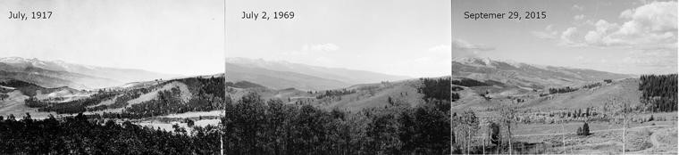
The project shows photographs of locations around Jackson Hole, Wyo., taken at the turn of the century in 1900. These photos can be easily compared to photos of the same locations from the 1970s, as well as between 2015 and 2018. This “repeat photography” allows land managers, biologists and ecologists to study the changes.
The project was the inspiration of George Gruell, a wildlife biologist for the Teton National Forest in the late 1960s and early 1970s. He saw it as a way to assess the condition and trends of the landscape.
“He went around and found all these historic pictures from the turn of the century from all the people who came here, then he spent a summer or two going out and trying to recreate pictures from where the picture was taken from,” said Andy Norman, a forest fuels specialist for the Bridger-Teton National Forest. “He did a technical publication in the ’70s on his work.”
Gruell took about 100 photos repeating the older photos. Those photos of Gruell’s have recently been taken again by Mike Merigliano of Driggs, who works with the national forest.
“So now we have photos from the turn of the century, 1970s and now 2015-18,” Norman said. “The difference between the ’70s and now is that we have other ways to display the data.”
That new way is found on the Forest Service’s website.
The site brings up an interactive map with pinpoints showing photo locations. When you click on a pinpoint, a display gives you information on ecological zones shown in the photo, years the photos were taken and all three photos individually and side-by-side. Another feature of the app gives viewers a sliding overlay for a detailed side-by-side comparison of the landscapes of past and present. Right now, there are 21 retake photos on the app, but plans are to eventually put all 100 or so photos on the website.
“Gruell was mostly interested in wildlife habitat and also how the vegetation had changed in the past 100 years,” Norman said. “More than anything he was interested in the effects of fire suppression. In the turn of the century, the Forest Service pretty much had a policy of fire exclusion.”
Although ecological change is constant, it generally moves at a slow pace. Taking a long-range look through retake photography gives land managers and scientists another tool for study.
The higher the elevation, typically, the slower change occurs, Merigliano said in a Jackson Hole News and Guide story.
“Up in the alpine,” he said, “the pictures I’m taking there, it looks like the guy was there yesterday. It just doesn’t change very much because it’s so cold.”
Other areas have shown bigger changes over time caused by road building, grazing, fire and even a dam break.
Merigliano told the Jackson Hole News and Guide that in studying the change in vegetation, invasive species such as cheatgrass have shown up in the latest photos.
The Forest Service app says the Jackson Hole area is ideal for this type of retake photography project.
“Wildlife habitat, especially for elk, and watershed protection were important priorities a century ago, and they remain so today,” the site says. “There are typical land management activities such as livestock grazing and timber harvesting, but some areas have never been grazed by livestock, and much of the landscape doesn’t have roads or timber harvest.”
Norman said the Forest Service plans to eventually put all of the retake photos on a database accessible by the public.
The project was partially funded by The Teton Conservation District.