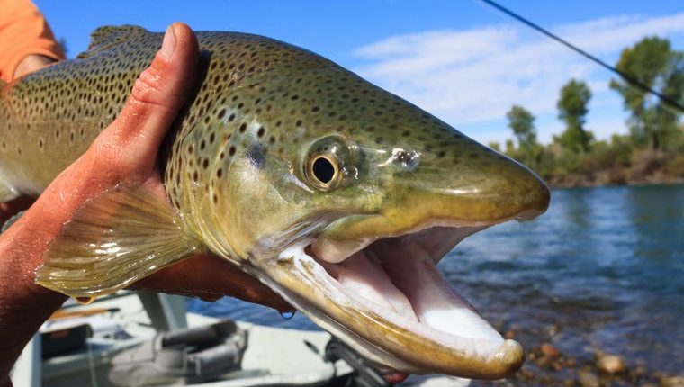
If you’re an angler looking for success this year in Southeast Idaho, remember this — reservoirs and lakes early, rivers and streams later.
This year is expected to be a banner year for fishing all across the state, thanks to a wet, snowy winter that has replenished Idaho’s once-suffering snowpack.
As we speak, Idaho’s water managers are dealing with an issue they haven’t dealt with in quite some time — there’s just too much water.
“There are no expected water supply shortages expected across 99 percent of the state,” Shawn Nield, Snow Survey Program manager for the Natural Resources Conservation Service in Idaho, said in a news release issued earlier this spring. “The greatest concern, especially in southern Idaho, is too much snow and how to safely release the excess water.”
What does this mean for anglers? A longer fishing season, more water for anglers to play in and a more plentiful fish population.
Though this snowmelt has filled many of Southeast Idaho’s reservoirs to near-capacity levels, it has flooded the region’s rivers and streams with strong currents, making it tough to catch anything right now.
Therefore, plan on hitting the reservoirs and lakes early in the season when they are topped off. Later, when the rainfall hopefully ends and irrigators begin to use the reservoirs’ water, be prepared to hit the rivers and streams hard.
But which fisheries will provide the best fishing this year? Here’s a short list of the best summer destinations:
Blackfoot Reservoir
The massive 18,000-acre Blackfoot Reservoir in Bingham and Caribou counties is always a popular destination for local anglers. But this year, the fishing is expected to be especially plentiful.
According to David Teuscher, regional fisheries manager for the Idaho Department of Fish and Game, the reservoir had some good carry-over water from last fall. This means that the reservoir’s water level did not get as low this past winter as it normally does, meaning a good fish survival rate.
“Blackfoot Reservoir carried over quite a bit of water, so I think we’re in for some good fishing there,” Teuscher said.
Though the sheer size of Blackfoot Reservoir is beneficial to boaters, those who fish from the bank do pretty well, too.
As for the Upper Blackfoot River, John Taylor, fishing guide at Element Outfitters in Pocatello, said to expect high water even after the waterway opens to fishing on July 1. However, the fish in both the Upper and Lower Blackfoot River should be biting.
“It was good last year and it should be good this year,” Taylor said.
American Falls Reservoir
This year, American Falls Reservoir is primed to become a massive fish factory.
For Pocatello-area anglers, this is great news, particularly after a horrendous 2013 and 2014 season on the reservoir located northwest of Pocatello. Fishing started to improve in 2015, followed by a much better year in 2016. Now, as the 2017 summer season is getting underway, anglers are looking forward to a return to the good old days of American Falls fishing.
Like the Blackfoot Reservoir, American Falls held a larger-than-average amount of carry-over water from last fall, meaning higher survival rates and potentially fatter fish.
There should be plenty of catchable trout in the reservoir itself, even now. But smallmouth bass fishing should be pretty hot below the dam this summer.
“Once the water warms up, the smallmouth will be aggressive,” Taylor said.
Chesterfield Reservoir
So far this year, Teuscher has heard reports of some big trout in the 3- to 4-pound range being caught at Chesterfield Reservoir on the east side of the Portneuf Range. But even if you can’t land a trophy, keep in mind that a large number of the fish stocked last fall have survived the winter, meaning there should be plenty of opportunities to make some great catches.
Because both are interrelated, if Chesterfield has a good year, you can expect the Upper Portneuf River north of Lava Hot Springs to follow suit.
Franklin County’s Reservoirs
There’s plenty of top-notch fisheries in the Pocatello area where the fishing should be phenomenal this year, but don’t forget to look farther south.
Taylor says it’s a good bet to take a look at one of the multiple reservoirs around Preston in Franklin County before the end of the year. These fisheries include, but are not limited to, Twin Lakes, Lamont, Condie, Foster, Glendale and Winder.
You also can’t go wrong at Treasureton Reservoir, where Taylor says to go early in the season for trout and later in the season for bass.
South Fork of the Snake River
Before opening Snake River Fly in Pocatello, Larry Larsen spent many years as a guide on the South Fork of the Snake River, which ends at Palisades Reservoir on the Idaho/Wyoming border.
Larsen said the South Fork has always been an incredibly hot location for fishing during big water years. Because this year’s winter has created a near-record-setting snowpack, he said to expect the South Fork to be one of the best places to fish in Southeast Idaho. However, you’ll have to wait a bit before heading out this summer.
“The South Fork of the Snake is probably going to be outstanding, but it won’t be until later,” he said. “Expect mid-July to the first of August.”
For 66 miles, the river flows through gorgeous mountain scenery. Among the most popular spots is the area in the Swan Valley region, where there’s lots of small islands, gravel bars and riffles to cast a line from, though this year the water will probably be pretty high well into the summer. Accessing the best fishing holes in this area will require the use of a drift boat.
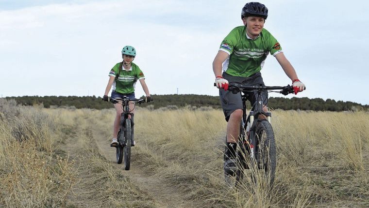
POCATELLO — Pocatello already has multiple trail systems, including City Creek on the westside and Blackrock/Chinese Peak to the south.
But if a proposal by a local group of trail users goes through, Pocatello might soon have another system east of the Highland neighborhood.
Bruce Olenick, regional administrator of the Idaho Department of Environmental Quality and a local trail advocate, asked the Pocatello City Council on April 13 to consider providing a portion of city land to access the proposed system, tentatively called the Pioneer Ridge Trail System.
There are multiple goals in Olenick’s proposal, including the creation of 20 miles of hiking, biking, horseback riding and limited ATV use trails at the Bureau of Land Management’s 1,400-acre East Bench Recreation Management Zone.
Other goals include providing more recreational opportunities on the east side of Pocatello and a home racing course for the local Pocatello Pioneers high school mountain biking team. The proposal also seeks to connect its trails with the Portneuf Wellness Complex and the Portneuf Greenway trails.
To determine the proposal’s feasibility and impact on local wildlife and natural resources, BLM will be drafting an environmental assessment. Then there will be a public comment period.
According to Blaine Newman, assistant field manager with the BLM, the project is in its very early stages and nothing has been approved or finalized yet.
However, if the project does goes through, it would involve constructing new trails while working to improve several of the existing trails on BLM property. Some of these trails are incredibly steep and would need to be made more accessible to trail users.
Blaine also said that it could be at least a year before any land development begins.
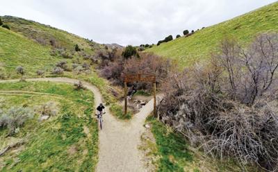
The City Creek Trail Management System is a beast, and we mean that in a really good way. Located right in Pocatello’s backyard, it boasts dozens of trails open to bike riders of all skill levels. We’ve been itching to include a comprehensive City Creek trail guide in our yearly mountain biking magazine for the past few years, but we always run into the same problem — our magazine is only 32 to 40 pages.
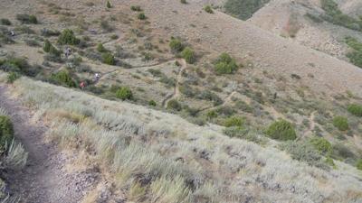
A biker heads back to the lower parking lot after riding the Bench Trail.
You could write a full-length novel on the trails, features and facets surrounding City Creek, and you’ll still miss something. But this year, we put together the most info-packed City Creek Trail Guide, detailing some of the most popular biking and hiking spots west of Pocatello.
The Lower City Creek Trail, located in the middle of this photo.
Upper and Lower City Creek
Level: Beginner to Intermediate
Ask a dozen bikers about their favorite City Creek trail and you’ll get a dozen different answers.
But in terms of the sheer volume of people, the Upper and Lower City Creek trail is arguably the most popular trail in the whole system. Every day during the warm months, bikers, hikers and families can be found enjoying the meandering, shady trail that runs “up the gut,” ultimately ending near the Sap Tree trailhead and the Kinport Peak Access Road.
For fitness enthusiasts, it’s easy to gauge your progress with all the numbered footbridges along the way, and the trail’s slow climb is ideal for beginner and intermediate riders.
However, there are a few obstacles along the way.
Between bridges 10 and 11 lies the aptly named “Heart Attack Hill,” a tough climb exceeding a 20 percent grade that is wildly fun to ride down. Up a little further near bridge 11, numerous other trails connect with Upper City Creek. There’s a smaller hill with numerous options forward. One route straddles the side of the hill, but beware — this route easily becomes very muddy, and riding too fast will send you on a nasty fall to the bottom of the creek.
You also need to be conscious of the crowds. Because the trail is so heavily used by hikers and families with small children, riding too fast and too carelessly could lead to collisions. Also, make sure to pay attention to signs — a portion of Lower City Creek Trail is a biker-one-way-uphill only from bridges 1 to 10.
Reese Ward, 7, riding up the Bench.
Bench, Fenceline, Rim and Bail
Level: Beginner
As you stand at the bottom of Bench Trail and look up the long, steep hill, your initial thoughts will depend entirely on your skill level.
An advanced mountain biker would happily say, “let’s go!” A timid beginner would probably get weak in the knees and decide to head over to the nearby bridge that leads to the Lower City Creek Trail.
That seemingly never-ending climb can be brutal on your legs, but the trip to the top is worth the pain. Once you’ve conquered the ride up Bench, the scene opens up to a variety of trails perfect for the beginner-level rider still learning to maneuver around ruts and minor obstacles.
One easy route that’s perfect for kids is the Bench, Fenceline, Rim and Bail loop. The organizers of Pocatello PedalFest use a part of this route for its kids-only Junior Race. Or, bikers can head up on Bench Trail, then ride down the duration of Lower City Creek Trail back to the main parking lot for some quick exercise.
Or they can head up Death Valley or Lifeflight to more difficult trails such as Lichen, Adrenalin or Sullivan’s. That’s the great thing about these lower bench trails — once you’ve mastered them, you have easy access to harder trails further up.
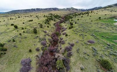
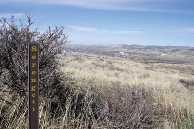
Serengeti offers sprawling views and gorgeous sagebrush habitat.
Cusick Creek Road, Serengeti, Lichen and Burrito
Level: Beginner to Immediate
Kirk Lepchenske, an avid mountain biker and employee with Barrie’s Ski and Sports, recommends the Cusick Creek Road-Serengeti-Lichen-Burrito loop as a fun route for advanced beginner and immediate riders.
To access Cusick Creek Road, take a drive up Fore Road to the parking lot behind the women’s prison. Here’s a forewarning to those new to the area — Cusick Creek Road is a monotonous grind that can be extremely wet during the early spring. With the heavy snow this winter, Cusick Creek overflowed this spring and turned the trail into a muddy mess early this season.
Then, right before you encounter the point when the trail crosses the creek, you’ll see the access point to Serengeti Trail on your right. Think of Serengeti as one of the major feeder trails in City Creek — if you’re lost, just find Serengeti and you’ll be able to orient yourself pretty quickly.
Compared to Cusick Creek, Serengeti is like a completely different world. You’ll totally understand why the trail is called Serengeti — if you ignore the sprawling view of Pocatello to your right, it feels like you are riding through Africa. The trail flows through gorgeous sagebrush habitat, with one particularly fun descent down a hillside.
Right after you pass the trailhead for Sullivan’s trail, turn right onto the mellow single-track Lichen trail, which meanders through a shallow draw. There’s nothing tricky or excessively difficult about Lichen — it’s just a pleasant ride down.
Eventually, you’ll come across the Burrito Trail. Take a right and ride on Burrito until it connects back to the Cusick Creek Trailhead. Just look for the powerstation.
If you’re not too exhausted from the loop, make sure to turn your bike around and head back down Burrito. Alan Worley, a mechanic at Barrie’s Ski and Sports, said Burrito is one of his favorite trails in the City Creek system because the corners link up well and you can develop some good speed.
One sidenote — if Cusick Creek is too impassable or boring for your tastes, take Bump Trail instead, which is a more traditional mountain biking trail. Bump eventually ends near the Serengeti/Cusick Creek connector.
Kirk Lepchenske takes a break along the shady Grove Trail.
Cone, The Grove, Outlaw, Black Cairn, Switchback and White Cairn
Level: Immediate
If you are looking for a true Western mountain biking experience that isn’t too challenging, check out this loop on the north side of the City Creek trail system.
Between bridges 11 and 12 of the Upper City Creek Trail, turn on to onto Cone. For a long time, the only way to get to the Grove Trail was by riding the motorized North Fork Trail located at the end of Cone. Thankfully, a local group of scouts recently built a new mountain biking trail on the hillside that runs parallel to North Fork.
Once you get past the switchbacks and drops on the aptly named Boy Scout Trail, you’ll connect with the Grove Trail. While somewhat technical, this trail will take you through a beautiful aspen tree grove, hence the name. The Grove is especially popular with local bikers because its a great ride regardless of the time of year. In the spring, the whole area is bright green with fresh vegetation growth. In the summer, the aspens provide plenty of shade from the brutal Idaho sun. In the fall, the autumn colors are simply majestic.
Once you reach the top, head over to Outlaw, which soon connects with the Black Cairn Trail. If you want to know everything that is great about mountain biking, head downhill on Black Cairn. Though steep, it’s an exhilarating ride down. Just keep a look out for hikers or other bikers.
Then, head over to Switchback, which features a curvy climb before dropping you off to White Cairn, which connects the upper parking lot to the Upper City Creek Trail. White Cairn is a generally easy uphill cooldown that travels through rolling meadows. In the end, you’ll end up at bridge 11, which is not too far from where you started.
911 is one of the most unique and fun trails at City Creek.
911 and Lifeflight
Level: Immediate
Out of all the trails at City Creek, 911 might be the most unique.
“You’re not going to find another trail like 911 around here,” said Cody Nelson, an employee with Barrie’s Ski and Sports.
This classic roller coaster-style trail travels through a gulley, which makes it like riding a half-pipe. It starts off relatively easy, but the further you go down, the faster and wilder it gets. Kids in particular tend to get a kick out of 911. Though some bikers claim you can get a tough workout riding up 911, it is strongly encouraged to go downhill only.
It’s recommended that only skilled riders take on the 0.75-mile downhill journey. For those bikers who are not prepared, there’s the adjacent Lifeflight trail that is bi-directional. The names of the two trails say it all about their differing intensities.
A word of warning — it is not uncommon for some hard-to-see holes, ruts and divets to develop near the bottom of 911 as the summer progresses. You can easily take a violent trip over your handlebars if you’re not careful.
Sullivan’s Trail is arguably City Creek’s most scenic ride.
Sullivan’s
Level: Intermediate
It’s been said that Sullivan’s Trail is the most scenic trail at City Creek. That’s saying a lot.
Whether you connect to Sullivan’s through Serengeti, Ritalin, Over the Top or Mushroom, the first thing you’ll notice is that no matter what direction you’re looking, the views are spectacular. In fact, you could probably call it the “Photography Trail” because of all of the opportunities for landscape and nature shots. Bring your camera.
The trail itself is a single-track that shouldn’t be much of a challenge for intermediate and advanced riders. Arguably, Sullivan’s probably works best as a hiking or jogging trail, since it’s easier to take in the landscapes and scenery when you’re on foot.
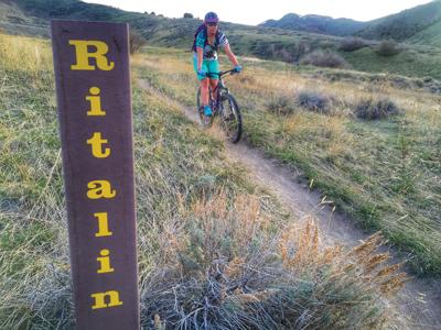
Brooke Ward heads along Ritalin Trail, which provides a short but thrilling ride.
Ritalin
Level: Intermediate
Why is this trail called Ritalin? Probably because you need total concentration when you ride it.
As you descend from the trailhead off Sullivan’s near the lone juniper tree, you’ll encounter some bermed corners before riding through some trees in a draw. Be careful in the draw because slippery mud can accumulate at the very bottom. After that, you’ll encounter a series of jumps before the trail meets up with Serengeti.
Ritalin may be short, but it’s a wild ride down. As the trail’s moniker implies, just make sure to keep your eyes on what you are doing — one momentary lapse of concentration can lead to a nasty spill.
Adrenalin
Level: Intermediate
Adrenalin might be listed on City Creek’s maps as a trail of Intermediate difficulty. However, this reporter has spoken to more than a fair share of experienced bikers who have injured themselves on this trail.
At first glance near the trailhead off Serengeti, Adrenalin doesn’t seem like much, but the wooden jump near the top should be an indicator of the exhilarating ride that awaits the thrill-seeking mountain biker.
Sap Tree
Level: Advanced
If you can make it up Sap Tree, you’ll discover the source of the trail’s name — a giant pine tree covered in sticky sap.
Sap Tree begins a few hundred yards up from the end of Upper City Creek Trail right where Kinport Road begins its ascent.
Many experienced local bikers enjoy this trail because of its beautiful woodland scenery and lack of traffic. There’s plenty to look at as you maneuver the trail’s rocky climbs, including diverse wildlife such as deer, moose and even a non-poisonous snake species called the rubber boa.
The trail is also seldom ridden due to its difficulty and isolation from the other trails at City Creek.
However, because of its high elevation and the heavy shade from the trees, it can take a long time before the trail dries out from the winter snow, especially with the nearby natural spring. So if you go early in the year, expect muddy conditions.
Lynda MacButch, who has been mountain biking for the past few decades, says Sap Tree is one of her favorite trails at City Creek.
“It’s a much better autumn ride when it’s drier,” she said.
Once you reach the notorious pine tree, you can continue forward but the trail quickly becomes very hairy, where you might have to carry your bike through some of the obstacles.
And whatever you do, don’t lean against the tree. You’ll be pulling sticky sap off yourself for the rest of the day. Just remember this about Adrenalin — once you get about half-way down, you’re not going to stop, brakes be damned. Just hold on, enjoy the ride and look out for other trail riders.
Aspen grove on the southern end of Sterling Justice Trail.
Sterling Justice
Level: Advanced
The Sterling Justice Trail, which was completed a few years ago, was named after the Portneuf River Ranger District’s first forest service ranger. But it could easily be called the Gateway, because it opens up a whole ‘nother world for City Creek bikers.
Sterling Justice’s main purpose is to connect the City Creek Trail System with Gibson Jack Trail, which is located further south. In turn, Gibson Jack connects to West Fork Mink Creek, which in turn provides easy access to the extensive Scout Mountain trails south of Pocatello.
Ideally, a mountain biker can start at City Creek’s main parking lot and bike to Scout Mountain and only cross concrete once — at the parking lot of West Fork of Mink Creek. From City Creek, Sterling Justice can be accessed from Cusick Creek Road just past the Over the Top trailhead.
Since its opening, Sterling Justice has won high marks for its scenic views. But unless you’re an advanced rider, there are numerous areas that can trip you up.
There’s a few big rock obstacles and a narrow section of the trail where you could fall off the mountain if you’re not careful. One hill in particular near Gibson Jack is the definition of a double black diamond trail. This hill’s descent is made up largely of loose rocks, and only the most skilled rider should attempt to tackle it.
If you can handle this trail, make sure to bring your camera with you on Sterling Justice. The panoramic views alone are well worth the trip.
The Mushroom Trail can stay muddy long into the riding season.
Mushroom and DNA
Level: Advanced
There’s something odd about the Mushroom Trail near the top of Upper City Creek Trail. No matter what time of year, the trail always seems to be muddy and slippery.
That’s partly because the trail is surrounded by majestic Aspen groves that block sunlight. While the scenery is lovely, the sudden drops, unsteady ground and sharp turns can leave even the most experienced biker laid out with a mouth full of Earth.
Eventually, the trail splits — one side leads to Over the Top and Sullivan’s, while the other route leads to DNA.
There’s a clear explanation as to why the one trail was named DNA — there’s a lot of blood and skin from all the crashes. There’s one particularly brutal hill about half-way down toward the Upper City Creek Trail.
Like Mushroom, DNA can be difficult to handle. Ride carefully.
Riders on Over the Top Trail.
Over the Top
Level: Advanced
For hardcore mountain bikers, there’s no better place to ride than the Over the Top Trail.
The trail features a little bit of everything — gorgeous scenic views, aspen groves, rock obstacles and lots and lots of switchbacks. In fact, one of the best places in the area to practice maneuvering technical switchbacks is at Over the Top Trail.
In the past, bikers had to pedal up the monotonous Cusick Creek Road to get to Over the Top’s trailhead. But recently, a more traditional mountain biking trail was constructed between the trailheads of Serengeti and Over the Top. It’s already proving to be far more popular than Cusick Creek Road.
When you start climbing up Over the Top, expect various switchbacks. Once you reach the crest, take a deep breath, enjoy the panoramic view, take a photo and begin your descent.
At first, it doesn’t seem like much, but soon you encounter the rock obtsacles and the techincal switchbacks that have made the trail so popular with hardcore bikers.
“It’s very challenging to make all the switchbacks without putting your foot down,” said Steve Romriell, a mountain biker who has ridden Over the Top multiple times. “I think I’ve done it once.”
By then, your heart is pounding and there should be a giant smile on your face as you soon descend into a series of aspen and cedar trees.
Eventually, the trail connects to the scenic Sullivan’s Trail, which can take you in a variety of directions. You could head up the rough and muddy Mushroom Trail toward Sap Tree. Or you could continue downhill, eventually hitting the fun 911 Trail before cruising down the Bench back to the lower parking lot. Or, if you’re not too exhausted and you’re looking for a killer workout, you could turn around and ride Over the Top back to Cusick Creek Road.
Whichever route you choose, you’ll never forget the exhilaration of tackling Over the Top.
Over the Top Trail is one of the best areas in Southeast Idaho to practice your technical switchback riding skills.
The City Creek Trail Management System is a beast, and we mean that in a really good way. Located right in Pocatello’s backyard, it boasts dozens of trails open to bike riders of all skill levels. We’ve been itching to include a comprehensive City Creek trail guide in our yearly mountain biking magazine for the past few years, but we always run into the same problem — our magazine is only 32 to 40 pages.
A biker heads back to the lower parking lot after riding the Bench Trail.
You could write a full-length novel on the trails, features and facets surrounding City Creek, and you’ll still miss something. But this year, we put together the most info-packed City Creek Trail Guide, detailing some of the most popular biking and hiking spots west of Pocatello.
The Lower City Creek Trail, located in the middle of this photo.
1. Upper and Lower City Creek
Level: Beginner to Intermediate
Ask a dozen bikers about their favorite City Creek trail and you’ll get a dozen different answers.
But in terms of the sheer volume of people, the Upper and Lower City Creek trail is arguably the most popular trail in the whole system. Every day during the warm months, bikers, hikers and families can be found enjoying the meandering, shady trail that runs “up the gut,” ultimately ending near the Sap Tree trailhead and the Kinport Peak Access Road.
For fitness enthusiasts, it’s easy to gauge your progress with all the numbered footbridges along the way, and the trail’s slow climb is ideal for beginner and intermediate riders.
However, there are a few obstacles along the way.
Between bridges 10 and 11 lies the aptly named “Heart Attack Hill,” a tough climb exceeding a 20 percent grade that is wildly fun to ride down. Up a little further near bridge 11, numerous other trails connect with Upper City Creek. There’s a smaller hill with numerous options forward. One route straddles the side of the hill, but beware — this route easily becomes very muddy, and riding too fast will send you on a nasty fall to the bottom of the creek.
You also need to be conscious of the crowds. Because the trail is so heavily used by hikers and families with small children, riding too fast and too carelessly could lead to collisions. Also, make sure to pay attention to signs — a portion of Lower City Creek Trail is a biker-one-way-uphill only from bridges 1 to 10.
Reese Ward, 7, riding up the Bench.
2. Bench, Fenceline, Rim and Bail
Level: Beginner
As you stand at the bottom of Bench Trail and look up the long, steep hill, your initial thoughts will depend entirely on your skill level.
An advanced mountain biker would happily say, “let’s go!” A timid beginner would probably get weak in the knees and decide to head over to the nearby bridge that leads to the Lower City Creek Trail.
That seemingly never-ending climb can be brutal on your legs, but the trip to the top is worth the pain. Once you’ve conquered the ride up Bench, the scene opens up to a variety of trails perfect for the beginner-level rider still learning to maneuver around ruts and minor obstacles.
One easy route that’s perfect for kids is the Bench, Fenceline, Rim and Bail loop. The organizers of Pocatello PedalFest use a part of this route for its kids-only Junior Race. Or, bikers can head up on Bench Trail, then ride down the duration of Lower City Creek Trail back to the main parking lot for some quick exercise.
Or they can head up Death Valley or Lifeflight to more difficult trails such as Lichen, Adrenalin or Sullivan’s. That’s the great thing about these lower bench trails — once you’ve mastered them, you have easy access to harder trails further up.
Serengeti offers sprawling views and gorgeous sagebrush habitat.
3. Cusick Creek Road, Serengeti, Lichen and Burrito
Level: Beginner to Immediate
Kirk Lepchenske, an avid mountain biker and employee with Barrie’s Ski and Sports, recommends the Cusick Creek Road-Serengeti-Lichen-Burrito loop as a fun route for advanced beginner and immediate riders.
To access Cusick Creek Road, take a drive up Fore Road to the parking lot behind the women’s prison. Here’s a forewarning to those new to the area — Cusick Creek Road is a monotonous grind that can be extremely wet during the early spring. With the heavy snow this winter, Cusick Creek overflowed this spring and turned the trail into a muddy mess early this season.
Then, right before you encounter the point when the trail crosses the creek, you’ll see the access point to Serengeti Trail on your right. Think of Serengeti as one of the major feeder trails in City Creek — if you’re lost, just find Serengeti and you’ll be able to orient yourself pretty quickly.
Compared to Cusick Creek, Serengeti is like a completely different world. You’ll totally understand why the trail is called Serengeti — if you ignore the sprawling view of Pocatello to your right, it feels like you are riding through Africa. The trail flows through gorgeous sagebrush habitat, with one particularly fun descent down a hillside.
Right after you pass the trailhead for Sullivan’s trail, turn right onto the mellow single-track Lichen trail, which meanders through a shallow draw. There’s nothing tricky or excessively difficult about Lichen — it’s just a pleasant ride down.
Eventually, you’ll come across the Burrito Trail. Take a right and ride on Burrito until it connects back to the Cusick Creek Trailhead. Just look for the powerstation.
If you’re not too exhausted from the loop, make sure to turn your bike around and head back down Burrito. Alan Worley, a mechanic at Barrie’s Ski and Sports, said Burrito is one of his favorite trails in the City Creek system because the corners link up well and you can develop some good speed.
One sidenote — if Cusick Creek is too impassable or boring for your tastes, take Bump Trail instead, which is a more traditional mountain biking trail. Bump eventually ends near the Serengeti/Cusick Creek connector.
Kirk Lepchenske takes a break along the shady Grove Trail.
4. Cone, The Grove, Outlaw, Black Cairn, Switchback and White Cairn
Level: Immediate
If you are looking for a true Western mountain biking experience that isn’t too challenging, check out this loop on the north side of the City Creek trail system.
Between bridges 11 and 12 of the Upper City Creek Trail, turn on to onto Cone. For a long time, the only way to get to the Grove Trail was by riding the motorized North Fork Trail located at the end of Cone. Thankfully, a local group of scouts recently built a new mountain biking trail on the hillside that runs parallel to North Fork.
Once you get past the switchbacks and drops on the aptly named Boy Scout Trail, you’ll connect with the Grove Trail. While somewhat technical, this trail will take you through a beautiful aspen tree grove, hence the name. The Grove is especially popular with local bikers because its a great ride regardless of the time of year. In the spring, the whole area is bright green with fresh vegetation growth. In the summer, the aspens provide plenty of shade from the brutal Idaho sun. In the fall, the autumn colors are simply majestic.
Once you reach the top, head over to Outlaw, which soon connects with the Black Cairn Trail. If you want to know everything that is great about mountain biking, head downhill on Black Cairn. Though steep, it’s an exhilarating ride down. Just keep a look out for hikers or other bikers.
Then, head over to Switchback, which features a curvy climb before dropping you off to White Cairn, which connects the upper parking lot to the Upper City Creek Trail. White Cairn is a generally easy uphill cooldown that travels through rolling meadows. In the end, you’ll end up at bridge 11, which is not too far from where you started.
911 is one of the most unique and fun trails at City Creek.
5. 911 and Lifeflight
Level: Immediate
Out of all the trails at City Creek, 911 might be the most unique.
“You’re not going to find another trail like 911 around here,” said Cody Nelson, an employee with Barrie’s Ski and Sports.
This classic roller coaster-style trail travels through a gulley, which makes it like riding a half-pipe. It starts off relatively easy, but the further you go down, the faster and wilder it gets. Kids in particular tend to get a kick out of 911. Though some bikers claim you can get a tough workout riding up 911, it is strongly encouraged to go downhill only.
It’s recommended that only skilled riders take on the 0.75-mile downhill journey. For those bikers who are not prepared, there’s the adjacent Lifeflight trail that is bi-directional. The names of the two trails say it all about their differing intensities.
A word of warning — it is not uncommon for some hard-to-see holes, ruts and divets to develop near the bottom of 911 as the summer progresses. You can easily take a violent trip over your handlebars if you’re not careful.
Sullivan’s Trail is arguably City Creek’s most scenic ride.
6. Sullivan’s
Level: Intermediate
It’s been said that Sullivan’s Trail is the most scenic trail at City Creek. That’s saying a lot.
Whether you connect to Sullivan’s through Serengeti, Ritalin, Over the Top or Mushroom, the first thing you’ll notice is that no matter what direction you’re looking, the views are spectacular. In fact, you could probably call it the “Photography Trail” because of all of the opportunities for landscape and nature shots. Bring your camera.
The trail itself is a single-track that shouldn’t be much of a challenge for intermediate and advanced riders. Arguably, Sullivan’s probably works best as a hiking or jogging trail, since it’s easier to take in the landscapes and scenery when you’re on foot.
Brooke Ward heads along Ritalin Trail, which provides a short but thrilling ride.
7. Ritalin
Level: Intermediate
Why is this trail called Ritalin? Probably because you need total concentration when you ride it.
As you descend from the trailhead off Sullivan’s near the lone juniper tree, you’ll encounter some bermed corners before riding through some trees in a draw. Be careful in the draw because slippery mud can accumulate at the very bottom. After that, you’ll encounter a series of jumps before the trail meets up with Serengeti.
Ritalin may be short, but it’s a wild ride down. As the trail’s moniker implies, just make sure to keep your eyes on what you are doing — one momentary lapse of concentration can lead to a nasty spill.
8. Adrenalin
Level: Intermediate
Adrenalin might be listed on City Creek’s maps as a trail of Intermediate difficulty. However, this reporter has spoken to more than a fair share of experienced bikers who have injured themselves on this trail.
At first glance near the trailhead off Serengeti, Adrenalin doesn’t seem like much, but the wooden jump near the top should be an indicator of the exhilarating ride that awaits the thrill-seeking mountain biker.
9. Sap Tree
Level: Advanced
If you can make it up Sap Tree, you’ll discover the source of the trail’s name — a giant pine tree covered in sticky sap.
Sap Tree begins a few hundred yards up from the end of Upper City Creek Trail right where Kinport Road begins its ascent.
Many experienced local bikers enjoy this trail because of its beautiful woodland scenery and lack of traffic. There’s plenty to look at as you maneuver the trail’s rocky climbs, including diverse wildlife such as deer, moose and even a non-poisonous snake species called the rubber boa.
The trail is also seldom ridden due to its difficulty and isolation from the other trails at City Creek.
However, because of its high elevation and the heavy shade from the trees, it can take a long time before the trail dries out from the winter snow, especially with the nearby natural spring. So if you go early in the year, expect muddy conditions.
Lynda MacButch, who has been mountain biking for the past few decades, says Sap Tree is one of her favorite trails at City Creek.
“It’s a much better autumn ride when it’s drier,” she said.
Once you reach the notorious pine tree, you can continue forward but the trail quickly becomes very hairy, where you might have to carry your bike through some of the obstacles.
And whatever you do, don’t lean against the tree. You’ll be pulling sticky sap off yourself for the rest of the day. Just remember this about Adrenalin — once you get about half-way down, you’re not going to stop, brakes be damned. Just hold on, enjoy the ride and look out for other trail riders.
Aspen grove on the southern end of Sterling Justice Trail.
10. Sterling Justice
Level: Advanced
The Sterling Justice Trail, which was completed a few years ago, was named after the Portneuf River Ranger District’s first forest service ranger. But it could easily be called the Gateway, because it opens up a whole ‘nother world for City Creek bikers.
Sterling Justice’s main purpose is to connect the City Creek Trail System with Gibson Jack Trail, which is located further south. In turn, Gibson Jack connects to West Fork Mink Creek, which in turn provides easy access to the extensive Scout Mountain trails south of Pocatello.
Ideally, a mountain biker can start at City Creek’s main parking lot and bike to Scout Mountain and only cross concrete once — at the parking lot of West Fork of Mink Creek. From City Creek, Sterling Justice can be accessed from Cusick Creek Road just past the Over the Top trailhead.
Since its opening, Sterling Justice has won high marks for its scenic views. But unless you’re an advanced rider, there are numerous areas that can trip you up.
There’s a few big rock obstacles and a narrow section of the trail where you could fall off the mountain if you’re not careful. One hill in particular near Gibson Jack is the definition of a double black diamond trail. This hill’s descent is made up largely of loose rocks, and only the most skilled rider should attempt to tackle it.
If you can handle this trail, make sure to bring your camera with you on Sterling Justice. The panoramic views alone are well worth the trip.
The Mushroom Trail can stay muddy long into the riding season.
11. Mushroom and DNA
Level: Advanced
There’s something odd about the Mushroom Trail near the top of Upper City Creek Trail. No matter what time of year, the trail always seems to be muddy and slippery.
That’s partly because the trail is surrounded by majestic Aspen groves that block sunlight. While the scenery is lovely, the sudden drops, unsteady ground and sharp turns can leave even the most experienced biker laid out with a mouth full of Earth.
Eventually, the trail splits — one side leads to Over the Top and Sullivan’s, while the other route leads to DNA.
There’s a clear explanation as to why the one trail was named DNA — there’s a lot of blood and skin from all the crashes. There’s one particularly brutal hill about half-way down toward the Upper City Creek Trail.
Like Mushroom, DNA can be difficult to handle. Ride carefully.
Riders on Over the Top Trail.
12. Over the Top
Level: Advanced
For hardcore mountain bikers, there’s no better place to ride than the Over the Top Trail.
The trail features a little bit of everything — gorgeous scenic views, aspen groves, rock obstacles and lots and lots of switchbacks. In fact, one of the best places in the area to practice maneuvering technical switchbacks is at Over the Top Trail.
In the past, bikers had to pedal up the monotonous Cusick Creek Road to get to Over the Top’s trailhead. But recently, a more traditional mountain biking trail was constructed between the trailheads of Serengeti and Over the Top. It’s already proving to be far more popular than Cusick Creek Road.
When you start climbing up Over the Top, expect various switchbacks. Once you reach the crest, take a deep breath, enjoy the panoramic view, take a photo and begin your descent.
At first, it doesn’t seem like much, but soon you encounter the rock obtsacles and the techincal switchbacks that have made the trail so popular with hardcore bikers.
“It’s very challenging to make all the switchbacks without putting your foot down,” said Steve Romriell, a mountain biker who has ridden Over the Top multiple times. “I think I’ve done it once.”
By then, your heart is pounding and there should be a giant smile on your face as you soon descend into a series of aspen and cedar trees.
Eventually, the trail connects to the scenic Sullivan’s Trail, which can take you in a variety of directions. You could head up the rough and muddy Mushroom Trail toward Sap Tree. Or you could continue downhill, eventually hitting the fun 911 Trail before cruising down the Bench back to the lower parking lot. Or, if you’re not too exhausted and you’re looking for a killer workout, you could turn around and ride Over the Top back to Cusick Creek Road.
Whichever route you choose, you’ll never forget the exhilaration of tackling Over the Top.
Over the Top Trail is one of the best areas in Southeast Idaho to practice your technical switchback riding skills.
The City Creek Trail Management System is a beast, and we mean that in a really good way. Located right in Pocatello’s backyard, it boasts dozens of trails open to bike riders of all skill levels. We’ve been itching to include a comprehensive City Creek trail guide in our yearly mountain biking magazine for the past few years, but we always run into the same problem — our magazine is only 32 to 40 pages.
A biker heads back to the lower parking lot after riding the Bench Trail.
You could write a full-length novel on the trails, features and facets surrounding City Creek, and you’ll still miss something. But this year, we put together the most info-packed City Creek Trail Guide we could fit into this magazine, detailing some of the most popular biking and hiking spots west of Pocatello.
The Lower City Creek Trail, located in the middle of this photo.
Upper and Lower City Creek
Level: Beginner to Intermediate
Ask a dozen bikers about their favorite City Creek trail and you’ll get a dozen different answers.
But in terms of the sheer volume of people, the Upper and Lower City Creek trail is arguably the most popular trail in the whole system. Every day during the warm months, bikers, hikers and families can be found enjoying the meandering, shady trail that runs “up the gut,” ultimately ending near the Sap Tree trailhead and the Kinport Peak Access Road.
For fitness enthusiasts, it’s easy to gauge your progress with all the numbered footbridges along the way, and the trail’s slow climb is ideal for beginner and intermediate riders.
However, there are a few obstacles along the way.
Between bridges 10 and 11 lies the aptly named “Heart Attack Hill,” a tough climb exceeding a 20 percent grade that is wildly fun to ride down. Up a little further near bridge 11, numerous other trails connect with Upper City Creek. There’s a smaller hill with numerous options forward. One route straddles the side of the hill, but beware — this route easily becomes very muddy, and riding too fast will send you on a nasty fall to the bottom of the creek.
You also need to be conscious of the crowds. Because the trail is so heavily used by hikers and families with small children, riding too fast and too carelessly could lead to collisions. Also, make sure to pay attention to signs — a portion of Lower City Creek Trail is a biker-one-way-uphill only from bridges 1 to 10.
Reese Ward, 7, riding up the Bench.
Bench, Fenceline, Rim and Bail
Level: Beginner
As you stand at the bottom of Bench Trail and look up the long, steep hill, your initial thoughts will depend entirely on your skill level.
An advanced mountain biker would happily say, “let’s go!” A timid beginner would probably get weak in the knees and decide to head over to the nearby bridge that leads to the Lower City Creek Trail.
That seemingly never-ending climb can be brutal on your legs, but the trip to the top is worth the pain. Once you’ve conquered the ride up Bench, the scene opens up to a variety of trails perfect for the beginner-level rider still learning to maneuver around ruts and minor obstacles.
One easy route that’s perfect for kids is the Bench, Fenceline, Rim and Bail loop. The organizers of Pocatello PedalFest use a part of this route for its kids-only Junior Race. Or, bikers can head up on Bench Trail, then ride down the duration of Lower City Creek Trail back to the main parking lot for some quick exercise.
Or they can head up Death Valley or Lifeflight to more difficult trails such as Lichen, Adrenalin or Sullivan’s. That’s the great thing about these lower bench trails — once you’ve mastered them, you have easy access to harder trails further up.
Serengeti offers sprawling views and gorgeous sagebrush habitat.
Cusick Creek Road, Serengeti, Lichen and Burrito
Level: Beginner to Immediate
Kirk Lepchenske, an avid mountain biker and employee with Barrie’s Ski and Sports, recommends the Cusick Creek Road-Serengeti-Lichen-Burrito loop as a fun route for advanced beginner and immediate riders.
To access Cusick Creek Road, take a drive up Fore Road to the parking lot behind the women’s prison. Here’s a forewarning to those new to the area — Cusick Creek Road is a monotonous grind that can be extremely wet during the early spring. With the heavy snow this winter, Cusick Creek overflowed this spring and turned the trail into a muddy mess early this season.
Then, right before you encounter the point when the trail crosses the creek, you’ll see the access point to Serengeti Trail on your right. Think of Serengeti as one of the major feeder trails in City Creek — if you’re lost, just find Serengeti and you’ll be able to orient yourself pretty quickly.
Compared to Cusick Creek, Serengeti is like a completely different world. You’ll totally understand why the trail is called Serengeti — if you ignore the sprawling view of Pocatello to your right, it feels like you are riding through Africa. The trail flows through gorgeous sagebrush habitat, with one particularly fun descent down a hillside.
Right after you pass the trailhead for Sullivan’s trail, turn right onto the mellow single-track Lichen trail, which meanders through a shallow draw. There’s nothing tricky or excessively difficult about Lichen — it’s just a pleasant ride down.
Eventually, you’ll come across the Burrito Trail. Take a right and ride on Burrito until it connects back to the Cusick Creek Trailhead. Just look for the powerstation.
If you’re not too exhausted from the loop, make sure to turn your bike around and head back down Burrito. Alan Worley, a mechanic at Barrie’s Ski and Sports, said Burrito is one of his favorite trails in the City Creek system because the corners link up well and you can develop some good speed.
One sidenote — if Cusick Creek is too impassable or boring for your tastes, take Bump Trail instead, which is a more traditional mountain biking trail. Bump eventually ends near the Serengeti/Cusick Creek connector.
Kirk Lepchenske takes a break along the shady Grove Trail.
Cone, The Grove, Outlaw, Black Cairn, Switchback and White Cairn
Level: Immediate
If you are looking for a true Western mountain biking experience that isn’t too challenging, check out this loop on the north side of the City Creek trail system.
Between bridges 11 and 12 of the Upper City Creek Trail, turn on to onto Cone. For a long time, the only way to get to the Grove Trail was by riding the motorized North Fork Trail located at the end of Cone. Thankfully, a local group of scouts recently built a new mountain biking trail on the hillside that runs parallel to North Fork.
Once you get past the switchbacks and drops on the aptly named Boy Scout Trail, you’ll connect with the Grove Trail. While somewhat technical, this trail will take you through a beautiful aspen tree grove, hence the name. The Grove is especially popular with local bikers because its a great ride regardless of the time of year. In the spring, the whole area is bright green with fresh vegetation growth. In the summer, the aspens provide plenty of shade from the brutal Idaho sun. In the fall, the autumn colors are simply majestic.
Once you reach the top, head over to Outlaw, which soon connects with the Black Cairn Trail. If you want to know everything that is great about mountain biking, head downhill on Black Cairn. Though steep, it’s an exhilarating ride down. Just keep a look out for hikers or other bikers.
Then, head over to Switchback, which features a curvy climb before dropping you off to White Cairn, which connects the upper parking lot to the Upper City Creek Trail. White Cairn is a generally easy uphill cooldown that travels through rolling meadows. In the end, you’ll end up at bridge 11, which is not too far from where you started.
911 is one of the most unique and fun trails at City Creek.
911 and Lifeflight
Level: Immediate
Out of all the trails at City Creek, 911 might be the most unique.
“You’re not going to find another trail like 911 around here,” said Cody Nelson, an employee with Barrie’s Ski and Sports.
This classic roller coaster-style trail travels through a gulley, which makes it like riding a half-pipe. It starts off relatively easy, but the further you go down, the faster and wilder it gets. Kids in particular tend to get a kick out of 911. Though some bikers claim you can get a tough workout riding up 911, it is strongly encouraged to go downhill only.
It’s recommended that only skilled riders take on the 0.75-mile downhill journey. For those bikers who are not prepared, there’s the adjacent Lifeflight trail that is bi-directional. The names of the two trails say it all about their differing intensities.
A word of warning — it is not uncommon for some hard-to-see holes, ruts and divets to develop near the bottom of 911 as the summer progresses. You can easily take a violent trip over your handlebars if you’re not careful.
Sullivan’s Trail is arguably City Creek’s most scenic ride.
Sullivan’s
Level: Intermediate
It’s been said that Sullivan’s Trail is the most scenic trail at City Creek. That’s saying a lot.
Whether you connect to Sullivan’s through Serengeti, Ritalin, Over the Top or Mushroom, the first thing you’ll notice is that no matter what direction you’re looking, the views are spectacular. In fact, you could probably call it the “Photography Trail” because of all of the opportunities for landscape and nature shots. Bring your camera.
The trail itself is a single-track that shouldn’t be much of a challenge for intermediate and advanced riders. Arguably, Sullivan’s probably works best as a hiking or jogging trail, since it’s easier to take in the landscapes and scenery when you’re on foot.
Brooke Ward heads along Ritalin Trail, which provides a short but thrilling ride.
Ritalin
Level: Intermediate
Why is this trail called Ritalin? Probably because you need total concentration when you ride it.
As you descend from the trailhead off Sullivan’s near the lone juniper tree, you’ll encounter some bermed corners before riding through some trees in a draw. Be careful in the draw because slippery mud can accumulate at the very bottom. After that, you’ll encounter a series of jumps before the trail meets up with Serengeti.
Ritalin may be short, but it’s a wild ride down. As the trail’s moniker implies, just make sure to keep your eyes on what you are doing — one momentary lapse of concentration can lead to a nasty spill.
Adrenalin
Level: Intermediate
Adrenalin might be listed on City Creek’s maps as a trail of Intermediate difficulty. However, this reporter has spoken to more than a fair share of experienced bikers who have injured themselves on this trail.
At first glance near the trailhead off Serengeti, Adrenalin doesn’t seem like much, but the wooden jump near the top should be an indicator of the exhilarating ride that awaits the thrill-seeking mountain biker.
Sap Tree
Level: Advanced
If you can make it up Sap Tree, you’ll discover the source of the trail’s name — a giant pine tree covered in sticky sap.
Sap Tree begins a few hundred yards up from the end of Upper City Creek Trail right where Kinport Road begins its ascent.
Many experienced local bikers enjoy this trail because of its beautiful woodland scenery and lack of traffic. There’s plenty to look at as you maneuver the trail’s rocky climbs, including diverse wildlife such as deer, moose and even a non-poisonous snake species called the rubber boa.
The trail is also seldom ridden due to its difficulty and isolation from the other trails at City Creek.
However, because of its high elevation and the heavy shade from the trees, it can take a long time before the trail dries out from the winter snow, especially with the nearby natural spring. So if you go early in the year, expect muddy conditions.
Lynda MacButch, who has been mountain biking for the past few decades, says Sap Tree is one of her favorite trails at City Creek.
“It’s a much better autumn ride when it’s drier,” she said.
Once you reach the notorious pine tree, you can continue forward but the trail quickly becomes very hairy, where you might have to carry your bike through some of the obstacles.
And whatever you do, don’t lean against the tree. You’ll be pulling sticky sap off yourself for the rest of the day. Just remember this about Adrenalin — once you get about half-way down, you’re not going to stop, brakes be damned. Just hold on, enjoy the ride and look out for other trail riders.
Aspen grove on the southern end of Sterling Justice Trail.
Sterling Justice
Level: Advanced
The Sterling Justice Trail, which was completed a few years ago, was named after the Portneuf River Ranger District’s first forest service ranger. But it could easily be called the Gateway, because it opens up a whole ‘nother world for City Creek bikers.
Sterling Justice’s main purpose is to connect the City Creek Trail System with Gibson Jack Trail, which is located further south. In turn, Gibson Jack connects to West Fork Mink Creek, which in turn provides easy access to the extensive Scout Mountain trails south of Pocatello.
Ideally, a mountain biker can start at City Creek’s main parking lot and bike to Scout Mountain and only cross concrete once — at the parking lot of West Fork of Mink Creek. From City Creek, Sterling Justice can be accessed from Cusick Creek Road just past the Over the Top trailhead.
Since its opening, Sterling Justice has won high marks for its scenic views. But unless you’re an advanced rider, there are numerous areas that can trip you up.
There’s a few big rock obstacles and a narrow section of the trail where you could fall off the mountain if you’re not careful. One hill in particular near Gibson Jack is the definition of a double black diamond trail. This hill’s descent is made up largely of loose rocks, and only the most skilled rider should attempt to tackle it.
If you can handle this trail, make sure to bring your camera with you on Sterling Justice. The panoramic views alone are well worth the trip.
The Mushroom Trail can stay muddy long into the riding season.
Mushroom and DNA
Level: Advanced
There’s something odd about the Mushroom Trail near the top of Upper City Creek Trail. No matter what time of year, the trail always seems to be muddy and slippery.
That’s partly because the trail is surrounded by majestic Aspen groves that block sunlight. While the scenery is lovely, the sudden drops, unsteady ground and sharp turns can leave even the most experienced biker laid out with a mouth full of Earth.
Eventually, the trail splits — one side leads to Over the Top and Sullivan’s, while the other route leads to DNA.
There’s a clear explanation as to why the one trail was named DNA — there’s a lot of blood and skin from all the crashes. There’s one particularly brutal hill about half-way down toward the Upper City Creek Trail.
Like Mushroom, DNA can be difficult to handle. Ride carefully.
Riders on Over the Top Trail.
Over the Top
Level: Advanced
For hardcore mountain bikers, there’s no better place to ride than the Over the Top Trail.
The trail features a little bit of everything — gorgeous scenic views, aspen groves, rock obstacles and lots and lots of switchbacks. In fact, one of the best places in the area to practice maneuvering technical switchbacks is at Over the Top Trail.
In the past, bikers had to pedal up the monotonous Cusick Creek Road to get to Over the Top’s trailhead. But recently, a more traditional mountain biking trail was constructed between the trailheads of Serengeti and Over the Top. It’s already proving to be far more popular than Cusick Creek Road.
When you start climbing up Over the Top, expect various switchbacks. Once you reach the crest, take a deep breath, enjoy the panoramic view, take a photo and begin your descent.
At first, it doesn’t seem like much, but soon you encounter the rock obtsacles and the techincal switchbacks that have made the trail so popular with hardcore bikers.
“It’s very challenging to make all the switchbacks without putting your foot down,” said Steve Romriell, a mountain biker who has ridden Over the Top multiple times. “I think I’ve done it once.”
By then, your heart is pounding and there should be a giant smile on your face as you soon descend into a series of aspen and cedar trees.
Eventually, the trail connects to the scenic Sullivan’s Trail, which can take you in a variety of directions. You could head up the rough and muddy Mushroom Trail toward Sap Tree. Or you could continue downhill, eventually hitting the fun 911 Trail before cruising down the Bench back to the lower parking lot. Or, if you’re not too exhausted and you’re looking for a killer workout, you could turn around and ride Over the Top back to Cusick Creek Road.
Whichever route you choose, you’ll never forget the exhilaration of tackling Over the Top.
Over the Top Trail is one of the best areas in Southeast Idaho to practice your technical switchback riding skills.
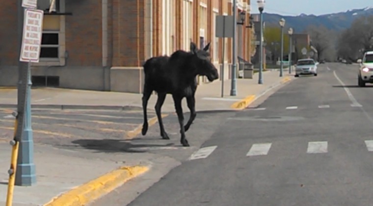
POCATELLO — Everybody has heard of the Easter Bunny.
But you could say on Sunday that Old Town Pocatello was visited by an “Easter Moose.”
A 13-second video submitted to the Idaho State Journal by Constance Bajerski shows a young bull moose running loose at Pocatello High School on Sunday afternoon.
Bajerski, who works for KISU at Idaho State University, said she was driving to her father’s house for Easter Dinner when something strange caught her eye at approximately 3:45 p.m. Upon closer observation, it turned out to be a moose hanging around the premises at Pocatello High School.
After identifying the animal, she turned off of North Arthur Avenue and drove behind the school on North Garfield Avenue, where she spotted the animal again. Then, she pulled out her cell phone and started filming.
“I was just in the right place at the right time,” she said. “I was just surprised I was able to get the video working so quickly.”
As the phone camera rolled, Bajerski said another car driving up North Garfield spooked the moose, causing it to run away from the side of the building and onto the road. Bajerski admits she is not experienced in filming wildlife, and the sight of the moose running on the road made her nervous.
“It was huge,” she said. “It was the size of a horse!”
Luckily, the moose ran south. Bajerski said she observed Pocatello police trying to “escort” the moose back to the foothills, with officers blocking traffic in Old Town as the moose made its way south. Officials with the Pocatello Police Department said officers worked to make sure the moose did not hurt anybody in the area.
When the Idaho Department of Fish and Game responded to Old Town, a conservation officer found the moose resting in the yard of a home on West Halliday Street. The moose had an injury to one of its antlers, and Fish and Game described the animal as “exhausted.”
Later, the moose moved on its own to a shady area near Centennial Park along the Portneuf River before safely heading back to its natural habitat in the foothills west of Pocatello.
As for Bajerski, she said she was a few minutes late for Easter dinner, but she had an excuse.
“I told my family, ‘Sorry I’m a little late but I ran into a moose,’” she laughs.
The U.S. Department of Agriculture’s Wildlife Services program announced on Monday that it has halted the use of M-44 predator control devices in Idaho. The announcement comes about three weeks after one of these devices injured a Pocatello boy and killed his dog.
Jason Suckow, western regional director of Wildlife Services, said in a letter that the federal agency will stop its use of M-44 devices on all private, state and federal lands in Idaho. Wildlife Services has also removed all of the M-44s currently deployed across the state.
However, the statewide moratorium is not permanent. Suckow’s letter states that Wildlife Services will provide a 30-day notice to conservation groups before placing any new M-44s in Idaho.
“This is an important victory, at least a temporary one, for both wildlife and for public safety across Idaho,” said Erik Molvar, executive director with Western Watersheds Project, in a press release. “We thank Wildlife Services for doing the right thing by removing these deadly and indiscriminate killing devices, and urge them to make the moratorium permanent.”
M-44s, also known as “cyanide bombs,” are spring-activated devices that release deadly sodium cyanide when activated. The USDA uses them to kill wild predators, such as wolves, coyotes and foxes.
Two weeks ago, a petition was filed by 19 conservation and wildlife organizations for an immediate ban on the use of M-44s in Idaho. The petition states that these devices have accidentally killed about 40 pet dogs over the past 20 years.
This petition was filed in response to an incident in Pocatello on March 16 that injured 14-year-old Canyon Mansfield and killed the teen’s dog, a 3-year-old Lab named Casey. Mansfield accidentally triggered an M-44 device that was planted on federal land about 500 yards behind the Mansfields’ property off West Buckskin Road. The USDA has confirmed that the device was planted by one of its employees.
Though the Mansfield family said Monday’s announcement of a statewide moratorium is a welcome first step, they still want to see more done on the federal level.
Recently, the Mansfields started a petition of their own on the White House’s petition website calling for new legislation they have named Canyon’s Law. It would permanently ban the use of M-44 cyanide devices across the United States. As of Monday evening, approximately 4,430 people have signed the petition.
The family noted that Canyon’s Law isn’t about punishing ranchers or farmers. Instead, it’s about ensuring that wild predator control is done humanely and precisely so people or pets are not inadvertently injured or killed.
“We believe the use of these devices is too indiscriminate and imprecise,” said Mark Mansfield, Canyon’s father and a local physician. “The ban in Idaho is an exciting first step. But we don’t want Wildlife Services to issue a temporary ban and then reinstate M-44 use once everything has blown over. That’s why we need a federal law like Canyon’s Law.”
The Mansfields have already spoken with U.S. Rep. Mike Simpson’s office to push for a federal ban, and they plan on meeting with legislators in Washington, D.C., over the next few months.
After Canyon was injured by the M-44 on March 16, he was transported to the Portneuf Medical Center in Pocatello for treatment. He was released a few hours later. But since the incident, Canyon has suffered frequent headaches, which the Mansfields have been told is a side effect of exposure to sodium cyanide.
The Mansfield family’s petition can be found at http://tinyurl.com/n7994sv.
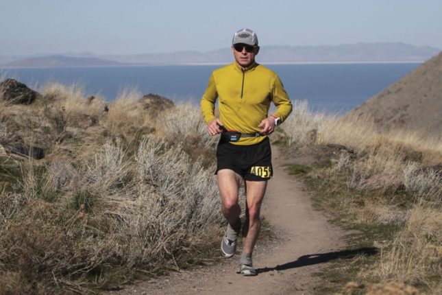
That’s what awaits Shawn Bearden next January. The Idaho State University professor is taking on the World Marathon Challenge, a grueling event where athletes run seven marathons on each of the Earth’s seven continents within one week.
Starting at the world’s end at Novo, Antarctica, Bearden and a handful of other competitors will then travel to Cape Town, South Africa; Perth, Australia; Dubai, United Arab Emirates; Madrid, Spain; Barranquilla, Colombia; and Miami, Florida.
At each stop, the competitors will run 26.2 miles before boarding a charter plane for the next continent.
Stigma
The World Marathon Challenge has been held since 2015 and draws a small handful of athletes from around the world each year. Just making it through the seven days is enough to secure lifetime bragging rights.
But Bearden isn’t competing for glory — he’s trying to raise awareness and end the stigma associated with depression, an illness he has battled his entire life.
Bearden, who serves as a professor of exercise science at ISU, said that on the surface, he always appeared to be a hard-working, driven, joke-telling and jovial academic.
But deep down inside, he has always dealt with sadness and despair.
“It’s affected me my whole life,” he said. “It got to a point a few years ago that if I hadn’t told me wife, I would have committed suicide.”
When he finally told his wife a few years ago, it was the first time he had ever openly spoken about his struggle with depression. Afterwards, he attended therapy and rehab to develop healthy coping skills to deal with his illness.
Since then, he says he has been much happier and wants to use his experience to tell others who also suffer from depression to tell somebody and get help.
“There’s a stigma that exists with depression that has to go away,” he said. “Nobody should be ashamed of it or hide it.”
Therapy
“Running for me is the core of my therapy,” Bearden said.
A lifelong athlete, Bearden is an avid trail runner who regularly logs 70 to 100 miles each week. He has participated in a variety of races including 10 ultra-marathons, winning one and coming in second place in another.
Ultra-marathons are long-distance footraces that continue for up to 50 or 100 miles. This year alone, he plans on competing in five ultra-marathon races.
He also hosts “Science of Ultra,” a podcast where he interviews the world’s leading scientists, coaches and athletes on ultra-marathons and racing in general.
With a doctorate in exercise philosophy, he said his knowledge of nutrition and science will serve him well during his seven-day globetrotting running adventure. He’s going to need it.
Hot and Cold
Hong Kong resident David Gething won the inaugural World Marathon Challenge in 2015. His interview with an Asian newspaper speaks volumes about the obstacles facing Bearden and the other competitors at the first marathon in Antarctica.
“Part of my toes are lost to frost bite, all the tendons in my feet are gone. My kneecaps are aching and it will take a few days’ rest before I can start to feel normal again,” Gething told the South China Morning Post after his victory.
Bearden admits that staying warm while running the four-loop course near Union Glacier is going to be a challenge. But the conditions won’t get any easier once the competitors travel to the other continents.
“The biggest challenge is managing rest and sleep, which is not an easy thing to do in this challenge,” Bearden said. “Due to the changing time zones, my internal clock is going to be out of whack.”
While running in subzero Antarctic temperatures will be difficult enough, he’ll be running in Dubai a few days later, where the temperatures can reach well above 100 degrees.
There also won’t be much time for sightseeing.
“We’ll have a little time for a shower and food at each place, but only for a couple of hours,” he said. “Then it’s onto the next continent.”
Money
If anything is going to stop Bearden from accomplishing his round-the-world run, it will be funds.
It costs $38,000 to compete in the World Marathon Challenge. As he raises money for the cost of the trip, a portion of the funds raised will go to iFred, the International Foundation for Research and Education on Depression. Bearded will run in the event as an ambassador for the charity.
To support Bearden’s efforts to end the stigma of depression, please visit GoFundMe.com/worldmarathons. As of Saturday evening, he has raised more than $3,000.